
Begin a Pleasants County Property Search
A Pleasants County property search usually starts with one of three clues. You might have a street address, an owner's name, or a rough idea of where the land sits. The county Assessor and the WV Property Viewer turn those clues into an assessment card. From there, the County Clerk's index takes you to recorded instruments. Be careful with spellings. A physical street label and an E-911 form can read differently. So can a mailing address and the legal description. Search more than one form and keep the parcel identifier handy. Before treating two hits as the same land, compare the card's Book/Page. It should match the recorded deed.
- Try MapWV Address mode with the street as written on a tax bill or deed.
- Try common abbreviations and spelling variants; open the parcel detail when a match appears.
- Write down Owner(s), PID, Book/Page, and legal description from the assessment report.
- Search the County Clerk IDX by owner as grantee and inspect the latest deed.
- Check the Sheriff's tax account and return to the map to confirm parcel context.
MapWV in the Pleasants County Property Search
The WV Property Viewer offers Parcel, Address, and Flood Zone modes. For a Pleasants County property search, Parcel and Address are the practical starting points. Flood Zone adds separate context. Selecting a parcel opens a details panel. The panel can include an assessment report, map view, flood information, and external map links. The Assessor's link page also ties together the local tax inquiry, deed inquiry, MapWV, state tax resources, and WVGenWeb.
| Field or Tool | What It Does | Search Note |
|---|---|---|
| Address | Locates a parcel from a street or E-911 form | Try 2ND and SECOND; a mailing city is not a boundary test |
| Parcel | Uses map or parcel identity to select land | Use the full district/map/parcel/suffix from a card |
| Flood Zone | Shows flood context | It is not an ownership or title field |
| Details / Highlight | Opens and emphasizes a selected parcel | Capture the PID before moving to adjacent parcels |
| Copy Link / Download KMZ | Preserves a map view or exports a visualization | A KMZ is not a certified boundary file |
The Pleasants Assessor resource page shows the county's linked search routes.
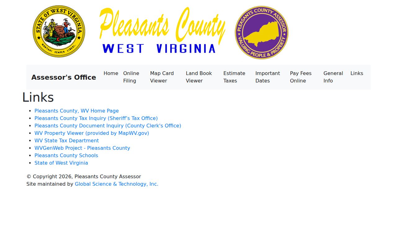
Use that hub to move among county and state tools. It does not merge their records into one result.
Address Variants in a Pleasants County Property Search
Pleasants County's sample assessment card offers a practical warning. The Physical Address reads "213 SECOND ST," but the E-911 Address reads "213 2ND ST SAINT MARYS WV 26170." The mailing address sits in a third field. A search built on one spelling may miss the card. The parcel may still be present. Try ST MARYS and SAINT MARYS. Drop punctuation, and remove a unit number if the field rejects it.
Belmont addresses raise the same concern. A postal label and ZIP will not tell you whether land sits inside the incorporated line. The county map archive keeps separate 01 Belmont Corp and 06 St Marys Corp folders. Treat the district and corporation line as a location clue. Then compare the legal description and PID. Rural place names such as Schultz or Hebron can appear in a deed or map. They may not belong to any city recorder's jurisdiction.
Keep the forms side by side in a search note. A physical street, an E-911 location, a tax mailing address, and a deed description answer different questions. An older deed may give an addition or lot rather than a street number. Once the current parcel is located, search that place name in the deed and plat index.
Read a Pleasants County Property Search Result
The assessment result for Pleasants County PID 37-06-0001-0096-0000 shows why a property search should capture more than the owner's name. This sample is a County Commission parcel marked X-Exempt. It is not a normal residence or a market-value comparison. Its fields demonstrate the structure of a result. That structure is not a promise that every parcel carries a value or building record.
| Owner(s) | County Commission of Pleasants County WV |
|---|---|
| Addresses | Mailing, Physical, and E-911 appear separately |
| Parcel identity | County, district, map, parcel, suffix, and root PID |
| Record link | Book/Page 225/608 and legal description |
| Land and values | Deeded acres, calculated acres, land, building, other improvement, and total appraisal |
| Class and use | X-Exempt and land use 604 in this sample |
The sample MapWV assessment detail exposes these fields.
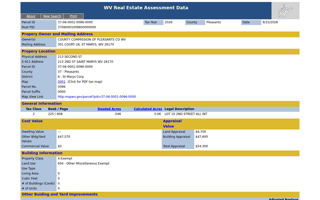
Read the displayed tax year and page date before calling a result current. The card can lag a newly recorded deed.
Carry a PID Through the Pleasants County Property Search
The sample PID has five parts. They are county 37, district 06, map 0001, parcel 0096, and suffix 0000. The detail page shows both the formatted ID and the root PID. Keep every part, zeroes and suffix included. Carry that whole string among MapWV, the assessment report, a map PDF, and a deed. The Clerk IDX is searched by names, dates, roles, books, and types rather than a map pin. The PID thus serves as a bridge to the deed's book/page and legal description.
Tax Inquiry works from a Map-Parcel label and an account number. Compare those values with the assessment card. Do not assume similar digits mean the same parcel. One deed can cover several parcels. A parcel can also be split or combined. Pleasants County mineral interests give another reason to check suffixes and legal language. An instrument may concern an interest that does not match the surface parcel in a simple way.
- PID
- A parcel key built from county, district, map, parcel, and suffix.
- Situs
- The physical location of the land, distinct from the tax-mailing address.
- Grantor and grantee
- The party conveying an interest and the party receiving it in an instrument.
- Book/Page
- The Clerk's recorded-volume reference shown on the assessment card.
Search the Clerk Index During a Pleasants County Property Search
When an assessment result names a current owner, take that name to the Pleasants County Clerk IDX. Search it there as grantee. The interface also offers grantor, creditor, debtor, direct, reverse, and other roles. Filters for Last/Firm and First fields, the Name control, date range, index group, document type, book, and name let a searcher narrow a broad result. A name can surface in marriage, birth, death, UCC, probate, or commission records. Type and role matter.
| IDX control | Observed use | Limit to keep in mind |
|---|---|---|
| From / Thru | Set a date window | January 1900 appeared as a default, not a confirmed coverage start |
| Party role | Search grantor, grantee, creditor, debtor, direct, reverse | Confirm the role on the returned instrument |
| Name | Last/Firm, First, or a separate Name field | Try entity, trustee, executor, and spelling variants |
| Type / Book | Filter deeds, liens, probate, UCC, and other groups | A property-related name hit may be unrelated to land |
The IDX result screen lists its columns plainly. They are Date, Document, Book Page, Pages, Name, Cross Date, and Instrument. The page also separates image, index, and vault modes. Login prompts do not mean every document image carries a charge. The county publishes no fixed image fee and no earliest online year. Ask the County Clerk before ordering. Ask which books and images are online and what a copy costs.
Use Results Without Confusing Records
One Pleasants County property search can surface several instruments tied to the same parcel. The list may include a deed, deed with plat, deed of trust, easement, right of way, release, judgment, tax lien, or transfer-on-death deed. Read carefully. A deed of trust records a financial encumbrance, not a new owner of record. A release clears one recorded claim without proving every other lien is gone. Check the document type and the parties before treating a line as a transfer. For subdivision work, search both PLAT and DEED with plat. St. Marys' Barkwill Addition and the original numbered lots on tax map 06-0004 make concrete starting terms. Belmont's district map folder offers a municipal clue, though the county publishes no full subdivision roster. Keep the parcel's map, current PID, old lot label, and deed book/page together so the Clerk or Assessor can separate a tract from a neighboring lot.
Map Results in a Pleasants County Property Search
Once a parcel is selected, MapWV offers several tools. These include Details, Highlight, Copy Link, Download KMZ, a tax-map PDF link, flood information, and links to outside map services. A saved map link lets anyone return to that exact parcel. A KMZ file can feed a local GIS view. It is not a survey or a certified boundary dataset. The Google, Bing, and OpenStreetMap links help with orientation only. When one of them disagrees with a tax layer, note the source. To study the area, open nearby selections one at a time and record each PID. A road, stream, railroad, or river channel is not automatically part of the adjacent lot. Easements and rights of way can cross a property without moving the parcel line. The Pleasants County parcel maps page explains the map legend. It also covers the tax-purpose warning that comes with it.
Check Dates in Pleasants County
The assessment sample shows a Tax Year 2026 label and a page date. Save both with your search notes. The Assessor updates the annual Real Estate Book from recorded deeds and wills. The county publishes no typical deed-to-roll delay. A newly recorded deed can therefore be more current. It may be more current than the owner on an older assessment card. Ask the Assessor whether a deed landed after the book cutoff. Confirm the transfer with the recorded instrument itself. The statewide voter lookup refreshes nightly. That schedule has nothing to do with property ownership. Pleasants County voter data is not a land record. It cannot show who owns a parcel. Keep each portal's own date and purpose attached to its result.
When Pleasants Search Needs Help
When MapWV misses an address, ask the Assessor for a scanned map card, land-book entry, district, and parcel key. Call 304-684-3132 or visit Room 103 at 301 Court Lane during listed office hours. Missing tax amounts or paid status go to the Sheriff/Tax Office at 304-684-2285, with the account or Map-Parcel in hand. For an unclear deed image, old volume, or instrument type, call the County Clerk at 304-684-7637 and ask about the public terminal, vault index, microfilm, and copy process. West Virginia Code §29B-1-3 lets a person ask a record's custodian to inspect or copy it, subject to exceptions. Name the parcel, the owner or party, the approximate date, the record you want, and the format. The county sets no universal copy fee or response deadline, so request an estimate before ordering a large file. A targeted request works far better than a general note sent to an office that does not hold the record.
Record boundary. An assessment search identifies the county's tax-roll entry. It does not prove clear title, settle a boundary, or replace the recorded instrument.